Forums (Forecast Builder)

Back

RE: Snowfall intensity calculations for Wx

ET
Edward Townsend, modified 8 Years ago.

Snowfall intensity calculations for Wx

Youngling Posts: 16 Join Date: 8/18/13 Recent Posts

Hello,

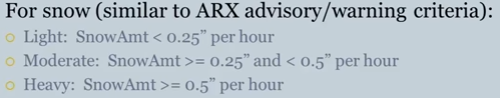
Per the PoWT training it mentioned the below image as the reference for snowfall intensity calculations:


Just curious, I was wondering what other methods of snowfall intensity have been looked at? Specifically could intensity be tied into visibility (e.g., via ASOS criteria or as suggested by Rasmussen 1999) especially with more offices going to Digital Aviation Grids?

Of note, Rasmussen 1999, used "Light, moderate, and heavy liquid equivalent snowfall rates ... defined as 0–1.0 mm/h, 1.0–2.5 mm/h, and greater than 2.5 mm/h, respectively, consistent with the usage by the Society of Automotive Engineers to characterize snowfall rates for deicing fluids." Though, admittedly, that usage is related to deicing and that application.

Pros and cons with both of these, however, I am looking to see what others thought and, more so, what else could be out there. Not easy. 

Thanks!


CG
Charles Greif, modified 8 Years ago.

RE: Snowfall intensity calculations for Wx

Padawan Posts: 27 Join Date: 9/10/15 Recent Posts

Thanks for the question and helping to expand this discussion, Edward!

The team will be looking at this, and other aspects of visibility, as it relates to DAS in the coming months and throughout the ForecastBuilder testbed. We appreciate your thoughts on the matter and will make sure they and others' are represented as we dig deeper into just how we can/should tie the Wx/PotFog grids to the Visibility DAS grids. 

...Chuck

AJ
Andy Just, modified 8 Years ago.

RE: Snowfall intensity calculations for Wx

Padawan Posts: 99 Join Date: 6/2/15 Recent Posts

Ed,

  Something too that would be very helpful for snowfall intensity calculation is to increase our temporal resolution of QPF. If we do hourly QPF, then we can have hourly snow (procedures are in place already to produce hourly snow if we did hourly QPF). Then from there yeah >1"/hr snowfall would give you heavy intensity.  One issue with the Visibility grid for intensity is sorting out say non-precipitating types from precipitating. You could have snow falling, but perhaps blowing snow or fog present as well. 

  Needless to say, a complex problem :)