All,
Resurrecting
this string of emails in the hopes of narrowing the list of
potential sources of the discontinuities in QPE. The state of
Colorado once again saw some pretty drastic differences across
RFC boundaries on 2/15. For the images in this email I will
focus on the Colorado RFC and Missouri RFC boundary along the
Park Range in northern Colorado. It's the western border of
Jackson County, eastern border of Routt County, bordered on
the north by Wyoming. On Feb 15th a nice snow event hit
northern Colorado. First, the AHPS 24 hr QPE for the 15th:
Next,
the AHPS QPE for the 16th. Note that most of the QPE fell
from 00Z on the 15th through 00Z on the 16th, but AHPS doesn't
allow 24hr amounts from 00Z to 00Z, so you'll have to mentally
add the 2 images.
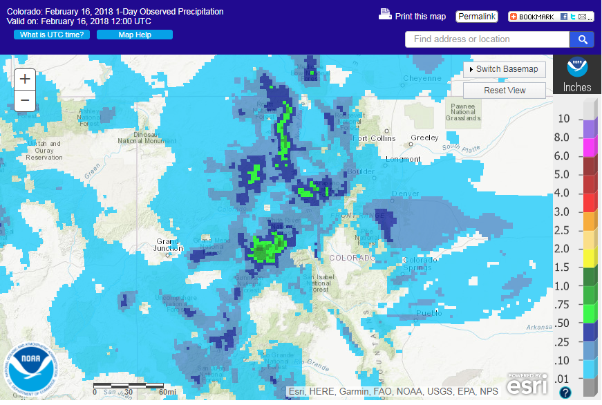
The
Park Range is the N-S oriented high QPE that starts at the
Wyoming border in the top center of both images. Notice that
pretty good QPE extends east of the max. For west upslope
events, the max in snowfall occurs along the terrain gradient
on the west side up to the ridge tops, but a lot of QPE "blows
over" to the east, sometimes all the way to the valley floor
in central Jackson County. Granted, it's FAR less in places
like Walden but on the east slopes of the Park Range, high QPE
can still occur. In fact, a CoCoRAHS observer on the east
side of Jackson County (well east of the traditional max along
the ridge top) had 0.60 liquid from 12Z 2-15 to 12Z 2-16. All
that said, these AHPS graphics seem to capture the real QPE
patterns and amounts well for northern Colorado. Keep this in
mind when you look at the URMA graphics next.
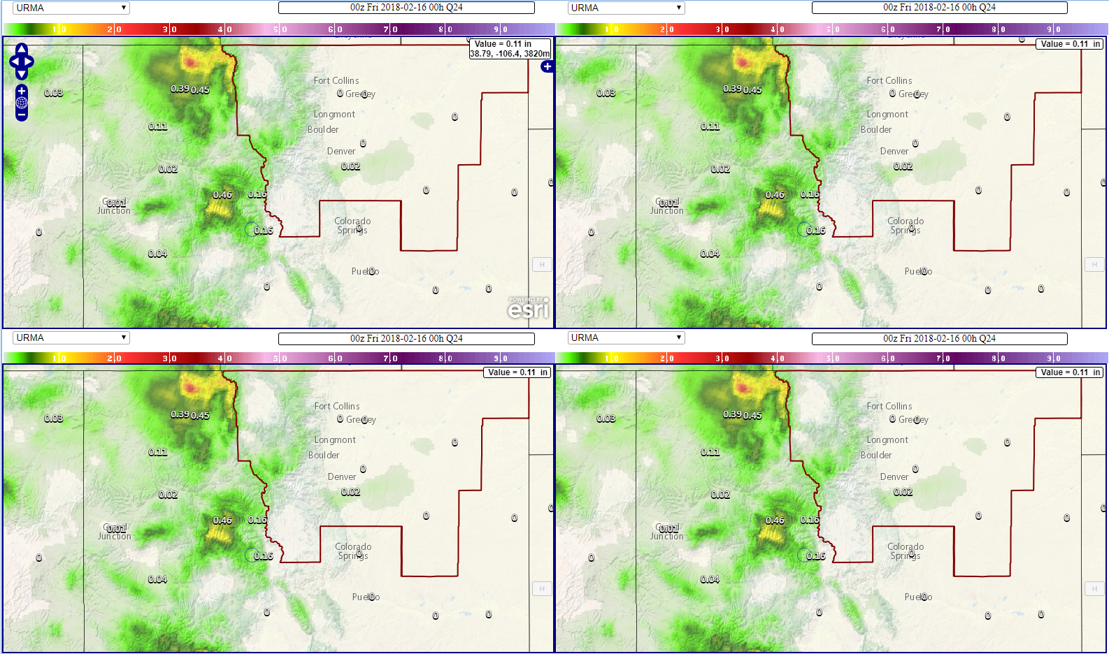
First,
what we get in GFE. We have 6 hour grids for URMA QPE. This
is a loop of the last 6 days of QPE. You'll notice that at
06Z on 2-15 there is high QPE Park Range for the Colorado RFC
side of the mountains but nothing on the Missouri RFC side.
This pattern of higher QPE in Colorado RFC vs. very little for
Missouri RFC continues until 18Z on the 15th. The east slopes
of Jackson into the north park area of Jackson county never
see any QPE for this event in URMA, despite a good amount
shown in AHPS. Again we feel AHPS is accurate while the URMA
QPE for this event is not.
Finally,
from the Veritas website the 24 QPE ending at 06Z 2-16 is
shown below.
I chose 06-06Z because that was the bulk of the precip event
in Jackson County. 00Z to 00Z would have shown pretty much
the same thing here. What it shows again matches what we have
for URMA in GFE. It is in stark contrast to AHPS QPE. It's
clear this URMA image is not taking advantage of CoCoRAHS and
the 0.60 amount 5-10 miles east of the max QPE. Further east,
across the Medicine Bow Mountains (eastern Jackson
County/Western Larimer County west of Ft Collins) where AHPS
has 0.3-0.6 total across the 2 days, URMA has 0.05 to 0.1. I
am not saying which is more correct in the Medicine Bows
because there are very few obs there, and no CoCoRAHS obs at
all.
The
question remains: Is URMA using the best available QPE
from the Missouri Basin RFC? Seems as though the AHPS page
QPE has higher quality data for our mountain sites across
northern Colorado. On the Colorado RFC side of our area the
URMA amounts look more realistic and in line with
observations.
Thanks,
Paul


